March 2016
ISRAEL PHOTOS VI -- ISRAEL REVISITED |
Nazareth Cliff
In previous websites I published results of research and exploration of Nazareth. Early travelers before the invention of the automobile observed Mary's Well where the local women stood in line waiting to fill their water jars. They described various churches built to commemorate the life of Jesus, Joseph and Mary. Some noted what they thought was the cliff that the Jesus' neighbors may have tried to throw Jesus to his death
from in their anger as described in Luke 4.
In 2016 I arrived in Nazareth. I went to the official Mt. Precipice with steep cliffs along its sides from which a fall might be fatal. From there I was able to look down on the ruins of platform and altar niche in a cliff on a high hill immediately to the west that others marked as the precipice from which the townspeople planned to hurl Jesus. I arrived in town and was introduced to a tour guide who told me he knew someone who had information about the cliff that was behind that Maronite Church in the neighborhood of the Basilica of the Annunciation and much closer to the site of first century Nazareth and the Jewish synagogue some people thought was near the green dome mosque. Rezik grew up in a house that was a short distance from the cliff. He used to play near the edge of the cliff when he was a boy. He said it was once ten to twenty meters high. The next day he produced a church publication stating early travelers reported it was fifty feet high.
Years ago there were large prickly pear cactuses growing near the edge of the cliff. Near the top there was a tunnel leading to a cave under his yard. The tunnel was about a meter high and led to a room 5 meters by 5-6 meters and about 2 meters high. Hermits used to inhabit the cave. His father bought a small piece of land in order to block the tunnel below his yard to prevent them from using the area as a campsite. The entrance to the tunnel was on another property and was later filled in. I asked him if building activities might have cut off the top of the cliff to make the area level for housing construction thus lowering the cliff. He told me, "No, the valley was raised up. When there was church or house construction in the area they dumped debris at the site of the cliff. It is expensive to transport debris from the area." He explained the cliff was
previously on municipal land. I assumed that no one complained about the dumping as it was public land. Recently a new mayor was elected and the land was transferred to a private citizen.
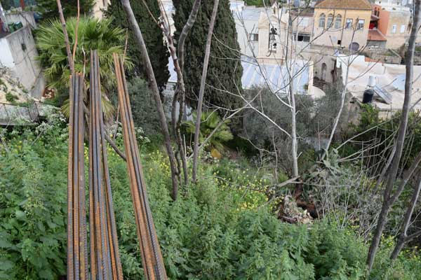
Rezik got permission from a neighbor for my tour guide and myself to see the edge of the cliff. I took photos.
March 2016
I also visited the house next door where he grew up. Next to Rezik's childhood home was a home where he said Simon Sigrudi was born and lived with nine older brothers and sisters. Simon Sigrudi was raised in a Salesian orphanage after his parents passed away. Simon Sigrudi became a Salesian monk and went to help teach Muslim orphans in Beit Jimal. Simon Sigrudi was credited with being present for the healing of a large number of people. His fame spread far. After he died the church investigated reports of these healings to determine if he should be described as a saint. He was described as blessed instead. People stood in line waiting for him to lay his hands on them. He had a reputation for having blessed hands.
I asked where the Salesian Orphanage used to be. My guide told me the current Salesian Church is where the Salesian Orphanage used to be. Some travelers described another steep cliff below this orphanage. The hill is covered with multistory buildings and concrete retaining walls that obscure its original configuration.
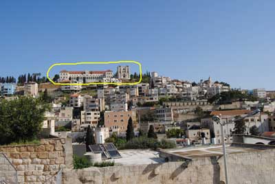
Salesian Property 2011
Before leaving Israel I went to Nazareth one more time to take photos from across the valley near the brow of the hill the Salesian Church is built upon. I was looking for the steeple of the Maronite Church and the red dome of the
Mensa Christi Church next door along with other landmarks familiar to me at this point. Tall buildings and steep terrain obscured my view in most places. I gathered enough visual evidence to determine the cliff
may have been accurately described as 10 - 20 meters high. I remembered Rezik told me the land directly behind the church used to be a small ditch or ravine. I realized the valley the Maronite Church is in
was probably deeper during Jesus' day before the Old Maronite Church was built.
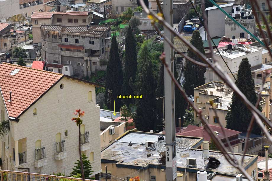
View of the Old Maronite and Mensa Christi Churches with cliff
in background March 2016
For previous research findings regarding the precipices of Nazareth see also:
Early
Descriptions of Precipices in Nazareth (Israel
Photos IV)
Traditional
Precipice SW of Town (Israel Photos IV)
Maronite
Church Cliff (Israel Photos V)
More Cliff
Photos (Israel Photos V)
Precipice
Writings from Israel Photos III:
Mt. Precipice
South Face
Summit
Over
the edge
Measuring
Line
View
of Nazareth from near Megiddo
Home Page
Written by David Q. Hall dqhall59@yahoo.com
May use photos and text for
non-profit publication. For profit usage subject to approval.
Nazareth Cliff
Cliff Survey
Cliff Cross Section
Gennesareth
Magdala
Old Tiberias
Sea of Galilee Fishing
Nain
Caesarea
Egypt in Ancient Israel
Khirbet Qeiyafa
Siloam